TTCM
()
> Weather
—
Monday,
May 6, 2024
—
W1
W2
W3
W4
96%
—
76°F
Washington, D.C., Weather
—
Sunrise: 6:04 (W1: 18%);
Solar Noon: 1:05 (W3: 52%);
Sunset: 8:06 (W5: 86%)
60
60
60
59
58
57
57
57
56
57
57
57
57
58
58
59
60
63
69
73
77
80
82
83
Last 72 Hours: Observations
—
Currently: 76°F
—
 —
Heavens-Above
—
Heavens-Above
74
71
69
67
65
66
66
65
65
65
64
64
64
66
67
71
72
74
76
77
78
79
80
79
78
76
73
71
70
68
68
67
67
67
67
66
66
68
71
74
78
81
83
85
86
86
85
84
...THE WASHINGTON NATIONAL DC CLIMATE SUMMARY FOR MAY 5 2024...

WEATHER ITEM   OBSERVED TIME   RECORD YEAR NORMAL DEPARTURE LAST
                VALUE   (LST)  VALUE       VALUE  FROM      YEAR
                                                  NORMAL
TEMPERATURE (F)
 TODAY
  MAXIMUM         72   3:59 PM  94    1928  74     -2       72
  MINIMUM         55   4:03 AM  39    1907  55      0       47
                                      1926
  AVERAGE         64                        64      0       60

PRECIPITATION (IN)
  TODAY            0.58          3.24 1953   0.12   0.46     0.00
  MONTH TO DATE    1.40                      0.62   0.78     0.01
  SINCE MAR 1      8.35                      7.33   1.02     5.16
  SINCE JAN 1     15.64                     12.81   2.83     8.89
Refresh
Hazardous Weather Outlook
Tonight: Showers and thunderstorms before 5am, then a chance of showers. Low around 65°. East wind around 5 mph becoming calm in the evening. Chance of precipitation is 80%. New rainfall amounts between a quarter and half of an inch possible.
Tuesday: A chance of showers, with thunderstorms also possible after 11am. Mostly cloudy, with a high near 80°. Calm wind becoming east around 5 mph in the afternoon. Chance of precipitation is 50%.
Tuesday Night: A chance of showers and thunderstorms, mainly before 2am. Mostly cloudy, with a low around 65°. Southeast wind 3 to 5 mph. Chance of precipitation is 30%.
Wednesday: A slight chance of showers and thunderstorms before 8am, then a slight chance of showers and thunderstorms after 2pm. Mostly cloudy, then gradually becoming sunny, with a high near 87°. Southwest wind 6 to 10 mph. Chance of precipitation is 20%.
Wednesday Night: A slight chance of showers and thunderstorms, then a chance of showers after 2am. Partly cloudy, with a low around 65°. West wind 3 to 6 mph. Chance of precipitation is 50%.
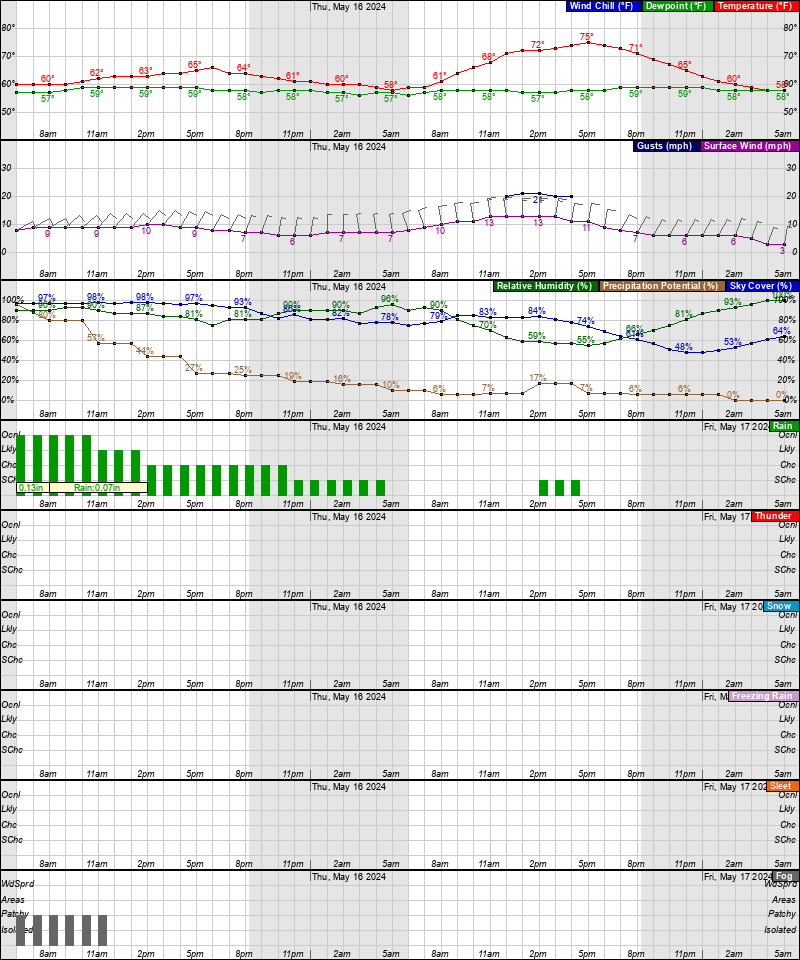
Thursday: A chance of showers and thunderstorms, then showers and possibly a thunderstorm after 8am. High near 80°. Chance of precipitation is 90%.
Thursday Night: Showers and possibly a thunderstorm before 8pm, then a chance of showers and thunderstorms between 8pm and 2am. Low around 61°. Chance of precipitation is 80%.
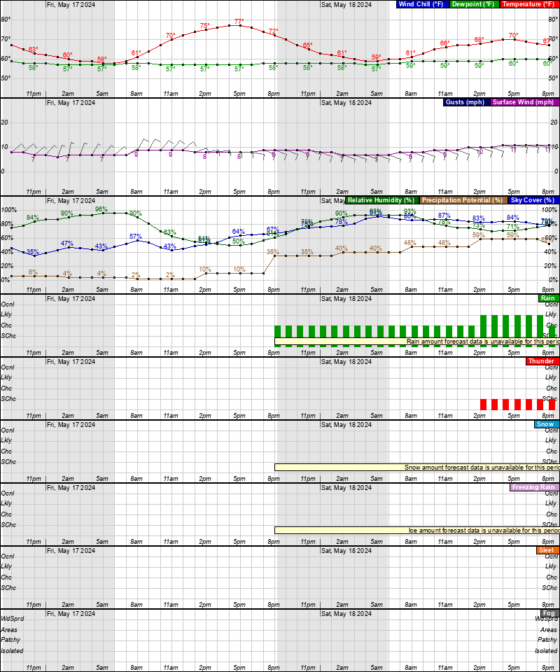
Friday: A chance of showers after 2pm. Partly sunny, with a high near 70°. Chance of precipitation is 40%.
Friday Night: A chance of showers before 8pm. Partly cloudy, with a low around 52°. Chance of precipitation is 30%.
Saturday: Mostly sunny, with a high near 69°.
Saturday Night: Partly cloudy, with a low around 53°.
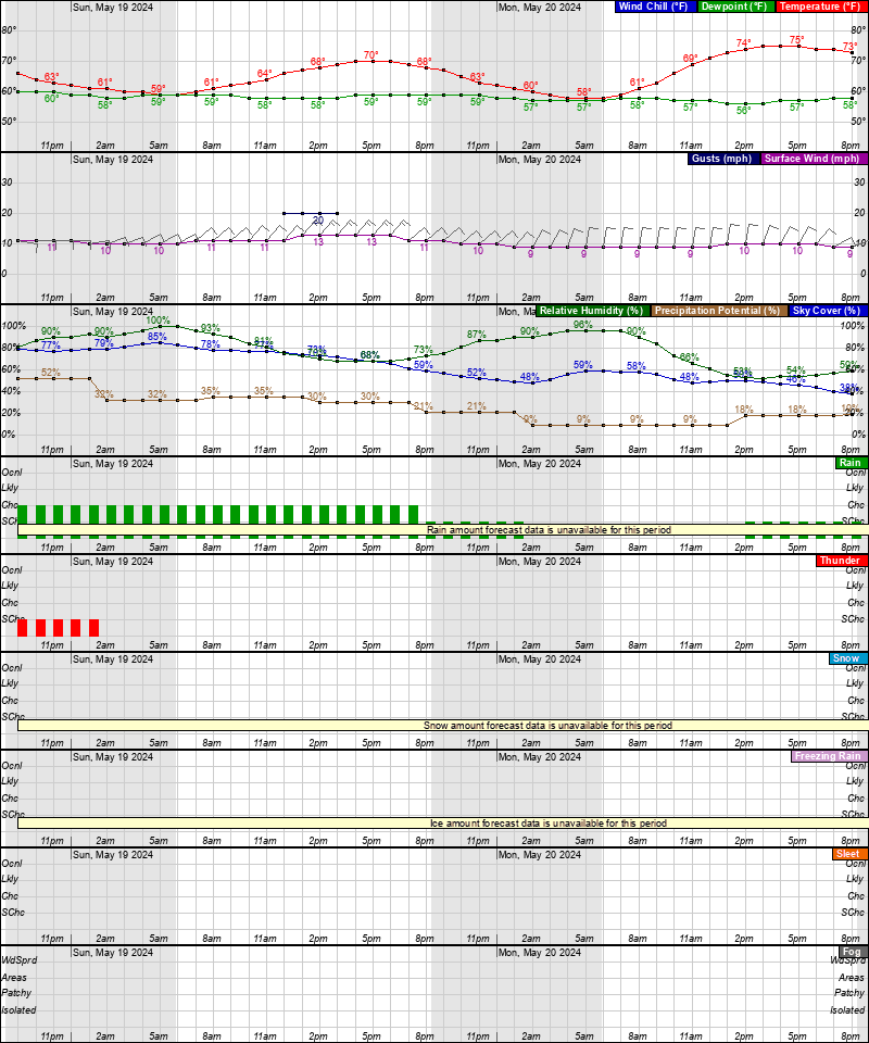
Sunday: A chance of showers. Mostly sunny, with a high near 70°. Chance of precipitation is 30%.
Sunday Night: A chance of showers. Partly cloudy, with a low around 52°. Chance of precipitation is 30%.
Monday: Mostly sunny, with a high near 75°.
Baltimore/Washington Forecast Office
Latest Forecast
Time and Date:
Today,
Sun-Moon,
Climate-Forecast
—
Light
ISS Sightings
—
Space Dashboard
Launch Calendars:
NASA,
KSC,
2019,
SFN,
SFI,
RLL,
SpaceX
Weather Prediction Center
•
Storm Prediction Center
•
Climate Prediction Center


Area Forecast Discussion
National Weather Service Baltimore MD/Washington DC
258 PM EDT Mon May 6 2024
.SYNOPSIS...
An active weather pattern will continue throughout this week with
daily chances for showers and thunderstorms. Storms may contain
heavy rainfall, gusty winds, and small hail. A strong cold front
looks to cross the region Thursday into Friday bringing an increased
threat for flooding and severe weather. Decreasing rain chances and
cooler conditions are expected as high pressure returns this
weekend.
.NEAR TERM /UNTIL 6 AM TUESDAY MORNING/...
Cloud bases continue to lift this afternoon with a few breaks of sun
across northern and central Virginia. With the breaks of sun,
showers and thunderstorms have bubbled especially across the
higher ridges of the central Blue Ridge, eastern northern neck
of VA and further south into the Roanoke/New River Valleys. WIth
the thinning cloud cover temperatures have climbed into the low
to mid 70s north of I-66/US-50 with near 80 degree readings
further south. Skies will remain mostly cloudy to overcast
through this evening as scattered shower and thunderstorm
activity increases with the incumbent trough ejecting from the
Ohio River Valley.
This disturbance will slowly drift east across the mountains this
afternoon before pushing toward the coast this evening and into the
first half of the overnight period. 12z hi-res CAM guidance
continues to highlight the 20-01z/4pm-pm window for the best
convective development. The HRRR/NAM seem to be the most
aggressive with convective development especially in areas along
and south of I- 66/US-50 as the vort axis and max PVA cross
during the peak heating period. The 12z ARW/NSSL are slightly
less, but show a similar theme of numerous showers and
thunderstorms starting west of the Blue Ridge this afternoon and
drifting east into the metros this evening.
The severe weather threat today appears to be low given the poor low
level lapse rates, deep saturation, and low shear (0-6km shear less
than 20 kts). MLCAPE values will range between 500-1000 j/kg north
of I-66 with 1000-1500 j/kg further south where a few breaks in the
clouds may occur. This is the area where one or two strong pulse
type thunderstorms look to occur with a brief gusts of wind, small
hail, and heavy rain as the primary concerns.
The bigger concern this evening will be heavy rainfall with a weak
surface trough extending west to east across the area. This trough
combined with slow moving thunderstorms this afternoon and evening
could lead to one or two instances of localized flash flooding. One
thing working into our favor is the recent week of dry weather and
the limited amount of rainfall over the weekend. Even with that
said, PWATS of 1.25-1.50 inches this afternoon and evening will
yield efficient rain producers out of any loosely organized
convection especially where the weak surface trough sets up.
Shower and thunderstorm activity should keep going through the first
half of the night as the shortwave trough drifts eastward across the
area. Patchy fog may again be possible during the second half of the
night. Lows overnight tonight should generally be in the low-mid
60s, with upper 50s in the mountains. Dewpoint values will remain in
the 60s leading to a muggy feel.
.SHORT TERM /6 AM TUESDAY MORNING THROUGH WEDNESDAY NIGHT/...
A stalled front nearby will maintain unsettled weather
conditions heading into the middle of the workweek. Additional
chances for scattered showers and thunderstorms exists each
afternoon although the threat for organized severe weather
threat remains low. Tuesday will feature brief mid-level ridging
which should suppress convection briefly before an approaching
trough reignites the threat Wednesday into Thursday.
Convection will be of the pulse variety or loosely organized Tuesday
given abundant cloud cover/convective debris over the region. More
of a focus turns toward Tuesday night as a complex of storms will
eject out of the Ohio River Valley. This convection will be in it`s
decaying phase as it works eastward heading into Wednesday morning
and could become a key player into how the severe weather and hydro
threat pan out Wednesday afternoon.
On Wednesday, the instability in the atmosphere will be greater
given a few more breaks in the clouds due in part to west to
southwest flow. This will allow for some downsloping and
compressional warming especially east of the Blue Ridge. The
combination of downsloping flow and subtle subsidence in the wake of
the decaying MCS Wednesday morning may inhibit a widespread severe
threat especially along and north of the I-66/US-50 corridor. EVen
with that said, scattered strong to severe storms remain possible
with the biggest concerns west of Blue Ridge. The primary threat for
storms over the next two days will be damaging winds and locally
heavy rainfall. Large hail up to 1" in diameter is also possible.
Temperatures will reach into the upper 70s and lower 80s on Tuesday.
Even warmer temperatures are expected on Wednesday, with highs
reaching into the mid-upper 80s.
.LONG TERM /THURSDAY THROUGH MONDAY/...
Unsettled weather continues through the end of the week as a wave of
low pressure develops over the area Thursday, then quickly pushes
northeast Thursday night. This is followed by a passing cold front
Friday. Expect several rounds of showers and thunderstorms to cross
the area, especially Thursday afternoon/evening.
Starting Thursday morning, widespread showers and storms are likely
to be ongoing around sunrise over the western half of the area as a
complex of storms from WV moves eastward. This early day convection
wanes and mostly dissipates by late morning. The big uncertainty for
Thursday will be how much instability can develop in the afternoon,
before the next round of storms develops. The ingredients are there
for severe storms to develop if we get instability that can combine
with forcing for ascent from the passing upper trough to the north
and bulk shear of 40-50 knots. SPC has placed areas east of the Blue
Ridge on a Day 4 Slight Risk for severe storms. Lingering
showers/storms Thursday evening dissipate after midnight, with
mostly dry and slightly muggy conditions overnight.
A cold front will cross the area Friday afternoon, bringing another
round of scattered showers and storms. Surface high pressure builds
into the area Friday night into Saturday, possibly bringing the
first day of mostly dry conditions areawide. Another reinforcing
upper trough moves through Saturday night into Sunday, maybe
bringing some scattered showers to the Alleghenies into northern MD.
Afternoon highs in the upper 70s to lower 80s Thursday drop to
slightly below normal values Friday into the weekend, with upper 60s
to lower 70s. Overnight lows follow the same pattern, dropping to
the 40s to low 50s over the weekend.
Latest Discussion
- Climate — Genesis 8:22
- While the earth remains, seedtime and harvest, cold and heat, winter and summer, and day and night shall not cease.
- Sea Level — Job 38:8-11
- Who shut in the sea with doors, when it burst forth and issued from the womb; when I made the clouds its garment, and thick darkness its swaddling band; when I fixed My limit for it, and set bars and doors; when I said, ‘This far you may come, but no farther, and here your proud waves must stop!’
About