TTCM
()
> Weather
—
Wednesday,
May 1, 2024
—
W1
W2
W3
W4
178%
—
N/A
Washington, D.C., Weather
—
Sunrise: 6:10 (W1: 22%);
Solar Noon: 1:05 (W3: 53%);
Sunset: 8:01 (W5: 83%)
60
60
60
59
58
57
57
57
56
57
57
57
57
58
58
59
60
63
69
73
77
80
82
83
Last 72 Hours: Observations
—
Currently: N/A
—
 —
Heavens-Above
—
Heavens-Above
71
69
68
66
65
64
63
62
63
64
68
72
77
82
84
86
87
88
91
89
88
85
82
80
77
75
73
71
70
68
67
66
65
65
66
67
70
73
74
78
79
79
79
77
74
71
67
64
...THE WASHINGTON NATIONAL DC CLIMATE SUMMARY FOR APRIL 30 2024...

WEATHER ITEM   OBSERVED TIME   RECORD YEAR NORMAL DEPARTURE LAST
                VALUE   (LST)  VALUE       VALUE  FROM      YEAR
                                                  NORMAL
TEMPERATURE (F)
 TODAY
  MAXIMUM         85   2:39 PM  92    1910  73     12       66
                                      1942
  MINIMUM         64   5:43 AM  34    1874  53     11       51
  AVERAGE         75                        63     12       59

PRECIPITATION (IN)
  TODAY            0.00          2.70 2014   0.12  -0.12     0.51
  MONTH TO DATE    2.06                      3.21  -1.15     3.55
  SINCE MAR 1      6.95                      6.71   0.24     5.15
  SINCE JAN 1     14.24                     12.19   2.05     8.88
Refresh
Tonight: Mostly clear, with a low around 61°. Light and variable wind.
Thursday: Sunny, with a high near 91°. West wind 3 to 8 mph.
Thursday Night: Mostly clear, with a low around 64°. Light and variable wind becoming northeast 5 to 7 mph after midnight.
Friday: Mostly sunny, with a high near 80°. East wind 9 to 11 mph.
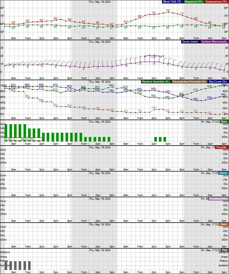
Friday Night: A chance of showers, mainly after 2am. Mostly cloudy, with a low around 55°. East wind 6 to 11 mph. Chance of precipitation is 30%.
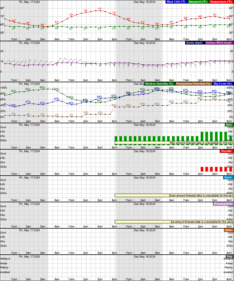
Saturday: A chance of showers. Cloudy, with a high near 64°. Chance of precipitation is 40%.
Saturday Night: Showers likely. Cloudy, with a low around 57°. Chance of precipitation is 70%.
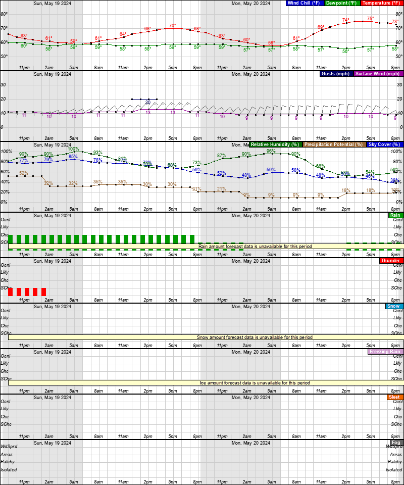
Sunday: Showers likely, mainly before 2pm. Mostly cloudy, with a high near 68°. Chance of precipitation is 70%.
Sunday Night: A chance of showers before 2am. Mostly cloudy, with a low around 60°. Chance of precipitation is 30%.
Monday: A chance of showers after 2pm. Mostly cloudy, with a high near 77°. Chance of precipitation is 30%.
Monday Night: A chance of showers and thunderstorms. Mostly cloudy, with a low around 62°. Chance of precipitation is 30%.
Tuesday: A chance of showers. Partly sunny, with a high near 81°. Chance of precipitation is 30%.
Tuesday Night: A chance of showers. Mostly cloudy, with a low around 65°. Chance of precipitation is 30%.
Wednesday: A chance of showers. Partly sunny, with a high near 87°. Chance of precipitation is 30%.
Latest Forecast
Time and Date:
Today,
Sun-Moon,
Climate-Forecast
—
Light
ISS Sightings
—
Space Dashboard
Launch Calendars:
NASA,
KSC,
2019,
SFN,
SFI,
RLL,
SpaceX
Weather Prediction Center
•
Storm Prediction Center
•
Climate Prediction Center


Area Forecast Discussion
National Weather Service Baltimore MD/Washington DC
256 PM EDT Wed May 1 2024
.SYNOPSIS...
Brief high pressure settles over the region today through Thursday
leading to a warm and dry conditions. A weak cold front will cross
the area late Thursday into Friday before sinking south this
weekend. An additional cold front and area of low pressure will pass
through the area Sunday into early next week. This will result in
increased chances for showers and thunderstorms along with cooler
conditions.
.NEAR TERM /UNTIL 6 AM THURSDAY MORNING/...
The cold front from yesterday continues to push south and east of
the region this afternoon while brief shortwave ridging/surface high
pressure takes over the lower Ohio River Valley. Outside of a few
mid and high level clouds mainly along and east of the Blue Ridge
mostly sunny skies prevail. High temperatures today will push into
the low to mid 80s with mountain locations remaining in the 60s and
70s. Humidity values will come down as well with dewpoints hovering
in the upper 40s and lower 50s this afternoon. Winds will remain
light out of the northwest at 5-10 mph with a few sporadic gusts up
to 15 mph (given terrain and bay breeze circulations).
High pressure slides over the southern Appalachians and southern
Blue Ridge this evening into Thursday leading to a continuation of
quiet weather conditions. Lows tonight will fall into the mid to
upper 50s with low 60s over the Baltimore/Washington DC metro areas.
Some patchy river and bay fog are possible although confidence is
lower for fog development given dry air advection moving in.
.SHORT TERM /6 AM THURSDAY MORNING THROUGH FRIDAY NIGHT/...
Upper level ridging firmly builds over the area Thursday leading
to a continuation of warm and dry conditions. 850 mb
temperatures will be back up around +14 to +18 degrees C with
PWAT values around 1". Meanwhile, a moisture starved cold front
will sit across far western portions of the forecast area acting
as a catalyst for perhaps an isolated mountain shower or
thunderstorm (chances less than 15 percent). Elsewhere across
the region expect dry conditions with passing fair weather
strato-cumulus during the peak heating of the day. High
temperatures will remain above average in the upper 80s and low
90s with upper 70s and low 80s over the mountains. Lows Thursday
night will fall back into the upper 50s and low to mid 60s.
By Friday, the weak cold front looks to cross the region. Once again
most areas will remain dry with high pressure slowly pushing
offshore and increased heights across the region. Some showers and
thunderstorms are likely over the mountains given added orographic
lift and increasing moisture from southeasterly flow. Temperatures
will remain above average with highs in the upper 70s and low to mid
80s despite increasing clouds.
The front will continue south of the region late Friday into
Saturday as strong high pressure over eastern Canada wedges south.
This will allow for onshore east to southeast flow to increase
across the area especially east of the Blue Ridge. As a result,
expect increased cloud cover, cooler temperatures, and rain at times
for the start of the weekend. Shower activity will be fairly
scattered throughout the day with even a few rumbles of thunder west
of the Blue Ridge and Allegheny Front where better heating can take
place. Overall we should remain stable limiting any severe weather
concerns. Locally heavy rainfall will remain possible especially
late Saturday into Sunday as an area of low pressure and cold front
move into the region. With that said, no washouts are expected, but
the increasing need for wet weather gear will come in handy this
weekend. PWATS will run 1.25 to 1.75 inches Saturday which is within
the 90 to 97.5 percentile of 30 year climatology for this time of
year. Rainfall amounts of a quarter to three quarters of an inch are
expected Saturday with an additional quarter to a half an inch
Sunday as the front passes through. High temperatures Saturday will
push into the upper 50s and low to mid 60s. Overnight lows Saturday
night will into the low to mid 50s. East to southeast winds will
remain sustained at 5 to 15 mph with gusts up to 25 mph at times
especially along the ridges/waters.
.LONG TERM /SATURDAY THROUGH WEDNESDAY/...
Unsettled weather returns for the weekend along and and ahead of a
surface low pressure and associated cold fronts that will impact the
region. Rain chances increase by late Friday night from west to
east. Saturday does not look like a total washout, with the better
forcing remaining off to the west. Nonetheless, off and on showers
will continue through the day on Saturday. Thunderstorm chances will
likely remain fairly low with the limited instability across the Mid-
Atlantic during that time. Highs will mostly be in the 60s for most
of the area Saturday afternoon.
By late Saturday night into Sunday, precipitation rates and
thunderstorm chances will likely increase. The front will slowly
cross the area and bring rainfall totals potentially beyond one inch
in localized areas. Given the drier antecedent conditions, isolated
instances of flooding will be possible on Sunday.
Afternoon showers and isolated thunderstorms will be possible Monday
and Tuesday as a result of a warm front lifting north of the area
and lingering moisture sticking around Tuesday with highs continuing
to climb across the area from 70s on Monday to low 80s by
Tuesday.
Latest Discussion
- Climate — Genesis 8:22
- While the earth remains, seedtime and harvest, cold and heat, winter and summer, and day and night shall not cease.
- Sea Level — Job 38:8-11
- Who shut in the sea with doors, when it burst forth and issued from the womb; when I made the clouds its garment, and thick darkness its swaddling band; when I fixed My limit for it, and set bars and doors; when I said, ‘This far you may come, but no farther, and here your proud waves must stop!’
About